A North to South hike across the Worlds steepest Island
The Pretty Island
La Palma is the northernmost of the Canary Islands, stretching over 708 square kilometres with a population of more than 85,000 citizens. Considered a hikers paradise, it is an island of incredible landscapes, magnificent volcanoes, dense pine forests, lush rainforests, springs, streams, waterfalls and magical star filled night skies. It is also known, justifiably so, as ‘The Pretty Island’.
The island is full of many interesting facts and wonders. It is classed as the steepest Island in the world at 2423 meters and some scientists believe runs along a fault line, which if triggered could cause a mega tsunami that could then sweep across the Atlantic ocean, reaching the East coast of America and causing devastating results.
The Island is so diverse that it ranges from jagged sea cliffs at its Northen edge, which then crosses through dense jungle, a series of narrow canals systems, alpine forests and ice capped volcanoes at its centre. The island then follows a ridge line with similar volcanic peaks until eventually heading down towards the sea to its Southern tip via ash laden paths.
During my research of the island I became fascinated by all the facts and wanted to explore this magical land by ways of a North to South traverse on foot.
For the expedition, I would be joined by Tim, a keen adventurer who was also my team mate during my Journey to the North expedition in January, and Alex, an experienced mountain and expedition leader, who had become a good friend whilst working together at the Bushcraft Company’s mountain centre the previous year. Alex would also be joining us as the expedition photographer.
Photo by Alex Frood
Day 1: Getting to the Northern tip.
Our journey started after landing at Santa Cruz airport on the east coast, from where we needed to head north to the northern most tip of the Island. The day had started later than planned, we stood patiently at the bus stop unaware that as we talked and waited, our bus had pulled into the stop on the opposite side of the road and left without us. We had been waiting at the wrong stop! Two hours later, after frustrated questions in the best Spanish we could muster at the information desk in Santa Cruz, and a long wait at the correct station, we finally boarded the bus and were on our way to the northern town Santa Domingo.
We arrived in Santa Domingo an hour and a half later at 3.30pm and set off on foot in search of the Northern most point of the Island, which we estimated was only about 6km away. It wasn’t long before we realised why the island had been given its title as the steepest, as we strenuously hiked and climbed up and down a series of coastal gullies. Our 6km estimate looked to double when we realised we had to trail around a further gully and then descend a steep winding path before reaching the furthest Northern point.
Photo by Alex Frood
We eventually reached the Northern point, but by now the night was beginning to draw in and our sights were set on finding shelter. After skirting around the coast, we found ourselves at a dead end, teetering on the edge of a cliff. Turning back we noticed some strange caves dotted along the cliff wall, which we decided to investigate in the hope that they would make suitable shelter for the night. On entering what was clearly a man made cave, we were taken aback to discover not only three beds and what looked like a well used kitchen, but also pornography plastering the cave walls. Beating a hasty retreat, we decided to put on our head torches and retrace our steps back up the winding path to a lesser porn filled cave we had discovered a couple of hours earlier. Here, we set down our backpacks, rolled out our sleeping bags and settled down for a night out of the elements.
Photo by Alex Frood
Day 2: Gaining some height
Waking up after a good nights rest in the cave, we packed up and rejoined the coastal path to head east, but by now we had realised these coastal gullies were going to take us much longer than first thought and we needed to sit down to consult our map and think of a plan B. Plan B was to head as high as we could inland to then contour around the roads, heading East towards the Cloud Forest, a mystical looking forest immersed in a thick cloud of fog. After the previous day’s struggle, endlessly climbing up and down steep, rocky inclines, Tim was suffering badly with sore and aching feet and reluctantly decided it would be better to find his way to the nearest town, get a taxi and meet us later that day.
Alex and I pushed on South up a never ending winding road. We knew that when we reached the main road junction at the top of this smaller road, that there would be the possibility of a shop or restaurant, meaning that we would be able to feed our craving for sugar with a bottle of coke or two. The road eventually cut off through a path of tall trees and skirted alongside the ridge until reaching the main road junction ahead.
Photo by Alex Frood
Our thought process had paid off and we were greeted by a small yet cozy bar, full of somber locals watching the La Palma vs Barcelona match. Glad to take the weight off our feet, we sat and hydrated and studied the map in depth, looking for the best possible route in order to reach today’s target, The Cloud Forest, where we would hook back up with Tim for the nights camp.
Back on our feet, we continued our journey, heading east following a small B road that skirted nicely around the ridge of the incline we had climbed. The smooth, even tarmac beneath our abused feet was a luxury! My love for this new road must have been obvious, as apparently I mentioned to Alex just how nice a road it was on more than one occasion… so he kindly reminded me.
Photo by Alex Frood
The road took us past a number of amazing view points, looking down towards the North at the path we had battled against so rigoursly for the past 24 hours.
According to our map we would reach a series of tunnels which would eventually lead us to a Laguna, from where we would contact Tim and see if he had managed to reach The Cloud Forest.
We passed through the tunnels one by one, one of which had a German film crew inside, filming a road bike ad. We could see why they would pick such a location, the views upon leaving the tunnel and emerging back into the daylight were incredible. We left the final tunnel and came upon signs directing us towards the lake. By now we felt truly shattered. It was 9pm and our bodies were aching. We had been walking uphill for over 12 hours and knew that we would need to push on until midnight in order to be able to reach Tim at The Cloud Forest.
Photo by Alex Frood
As we drove on, we decided that once we reached the Laguna campsite, we would sit and rest for a while and try and get a message to Tim. We pressed ahead, looking forward to the brief respite, but as we approached the camp we were greeted by torch light and a familiar sounding voice, it was Tim, and boy were we glad to see him!
Tim had saved our aching legs and had also arranged for us to stay at the campsite for the night. He had stoked up a roaring fire and stocked up on a huge array of goodies to welcome us. This was a very welcome surprise and a huge morale boost ahead of tomorrows big hike through The Cloud Forest.
Day 3: Through the Cloud Forest
After a good feed and a well deserved rest, the three of us left the comfort of the campsite to set off once again. The path we followed was now winding upwards through the foothills of the volcano and deep inside the humid cloud forest, located to the North East of the Island.
After two hours of winding paths we stopped at an information centre that generously provided us with lunch for the day, a strange mix of potatoes with a pepper and cheese sauce, that didn’t taste quite as nice as it sounded. Despite the previous day’s decision to give his aching feet a rest, Tim was suffering once again. His feet still too sore for the hours of hiking ahead whilst bearing a heavy rucksack, he decided he would take the path down into town and meet us the following day at one of the Islands refuges that sits along the ridge line of the volcanic crater.
Photo by Alex Frood
Powering on, Alex and I soon came to realise that we had seriously underestimated the shear steepness of the island and we would have to try and cover alot more ground today than we had initially thought. Muscles burning, we marched on up the rocky track and set a staggering pace through the humid forest. Reaching a fork in the path that was unmarked on our map, we made a calculated judgement and eventually chose our route, believing that this direction would eventually lead us to a series of narrow tunnels situated deep inside the Cloud Forrest, that act as a canal system to supply the Island with its vital water supply.
We walked for hours without reaching the tunnels and started to worry that the path we had chosen was the wrong one. After we started to clamber up an overgrown cliff side, we knew that we had indeed taken a wrong turn. Deflated and tired, but still determined, we turned around and headed back down, this time taking a path that would lead us through a narrow steep sided gorge. We now knew this was our correct route and would eventually lead us up to the tunnels
Photo by Alex Frood
After what seemed like forever and much later than planned, we finally reached the narrow tunnels and with headlamps strapped on, we would now have to crouch down and clamber through each of them, one by one. Dark and dank, the tunnels stretched to distances of up to 500 meters in length and had water pouring down through the cracks of the roof. Scrambling through this unusual setting, our journey through the tunnels was beginning to feel like one crazy adventure and reminded me of the scene in The Goonies where they shot down the water slide to reach the lost pirate ship of One Eyed Willy.
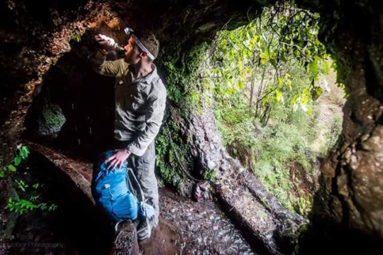
Photo by Alex Frood
But there was no pirate ship and instead we reached a small refuge where the canal system ended. Alex and I decided this was an ideal place to stop for a break and have a foot spa and wash while we still had access to running water.
We had left the cloud forest and were faced with a steep incline through an alpine forest. It was now dark and keeping to the path was a continuous struggle. We had entered the snow line which continued to get deeper and deeper with every step. We lost the path in the dark snowy conditions, but knew that if we just kept heading upwards we would reach the Islands high mountain road.
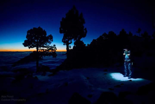
Photo by Alex Frood
The path became laden with thick scrub like bushes, which we had to fight with all our might against to get through. Eventually we met the road and aimed to find the mountain refuge which sat 100 meters short of the Islands highest summit, Roque De Los Mouchosos.
The snow was now thick and icy and the weather had changed from hot humid jungle to below freezing alpine conditions, all in the space of a few hours. As we started walking along the road we stumbled upon an abandoned car, which had succumbed to the frozen conditions. A stark reminder of what was to come.
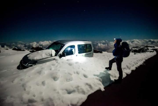
Photo by Alex Frood
After another hour of walking we reached the mountain refuge, but to our horror it was locked. By now it was midnight, it was cold and we were just too tired to let the disappointment get to us. Both craving sleep, we decided to pitch our tents and brave the cold night ahead high on this icy mountain peak.
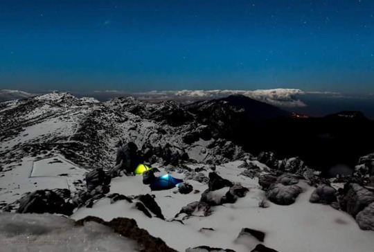
Photo by Alex Frood
Day 4: Traversing the ridgeline
During the night the temperature dropped dramatically and the wind was ferocious against the tent walls. It was 7am and I knew it was time to get up and get moving, but also very conscious that I hadn’t managed to sleep a wink. As I lay there willing myself to climb out of my sleeping bag, Alex popped his head into my tent, “Chaz come and see this”. I stepped out to the most amazing sunrise I have ever witnessed, the sky was a bright orange glow and the valley below was filled with a spectacular cloud inversion. The sheer sight of what we had accomplished the day before was just incredible and I knew the views would keep getting better and better as the day would go on.
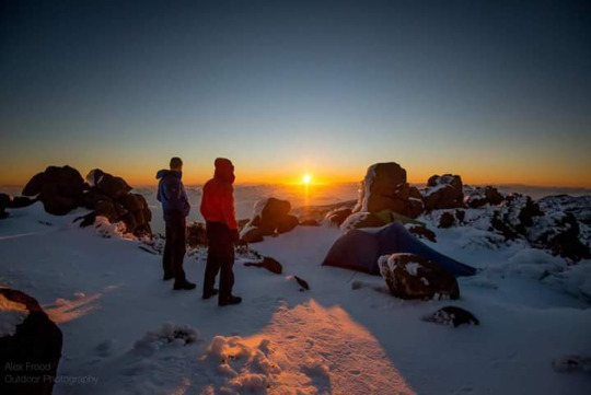
Photo by Alex Frood
After a frosty pack down of the tents, we set off to rejoin the high mountian road towards the Islands highest point. The Island was experiencing colder than usual weather conditions and we were stopped by a news crew wanting to film the two crazy walkers braving the elements. Happy to oblige, we walked off with the cameras pointing at our retreating backs. Feeling very aware we were being filmed, walking suddenly became a tricky task and I very nearly slipped, almost making it a very embarrassing TV appearance.
Managing to stay upright, however, we continued on our journey towards our next goal. After another hour of uphill hiking and trying our luck with another short cut fighting our way through thick scrub like bushes, we were tired and drained of energy. But we had to continue! The sun was beaming down on us and all we could think about was getting to the top and being able to stop walking uphill. With that thought in mind, we mustered up the last of our failing energy and finally reached the summit with a feeling of total elation. We had summited the Islands highest point at 2423m.
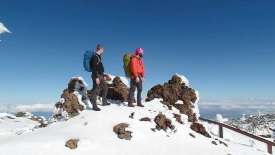
Now we had to choose the safest but quickest route heading south and down towards the ridge line of the volcano. Rather than heading back down the road, we decided it would be best to stick to the snow laden path to try and cut across and then drop back down onto the road. It started off well, we quickly covered some miles sliding down the slopes past the various mountain top observatories. But we then hit several areas where the soft snow was too shaded from the suns rays and became treacherously icy instead. After a couple of wasted hours, slowly and carefully treading this dangerous path, we eventually managed to drop down back onto the road.
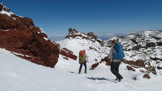
Sticking to the road, we covered several kilometers fairly quickly and managed to make up for some of the time lost on the ice. We reached a point where the road had been blocked off from cars. Here we found families with their children making the most of the snowy conditions, riding sledges and having snowball fights. We cut off from the path here to make our way back towards the ridgeline.
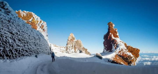
Photo by Alex Frood
The snow filled path became deeper, making each step more of an effort and we had to keep stopping to catch our breath. Fighting through the snow, we eventually reached the ridgeline and started making our way up and down several smaller summits on our way south. The ridgeline was fast becoming more and more icy and dangerous, and we found ourselves taking more and more risks to get across its ledges. Clinging to the mountainside, we scaled ledges with just an inch of icy foot space and a sheer vertical drop below them. I have summited many peaks in my life, but here I was more than out of my comfort zone and we were unprepared and unequipped for the terrain we were trying to walk across. Once again, I was forced into realising just how much we had seriously underestimated this Island.
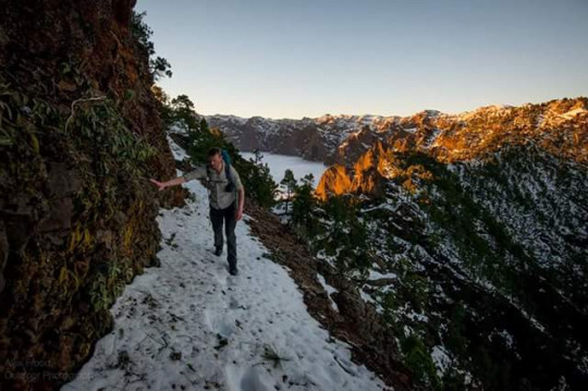
Photo by Alex Frood
As the night started to draw in we reached a high mountain refuge sat delicately on the edge of the ridge. We entered to be greeted by two friendly German hikers who welcomed us and urged us to stay for the night. By now I was seriously tired and frustrated with this dangerous icy ridge and felt that if we carried on much longer we were at risk of making clumsy, life threatening mistakes. But we had recieved word from Tim who was about 10km away at another refuge and he was waiting there with hotdogs and hot chocolate. We were tired, but we were also hungry and the temptation got the better of us. To the horror of our new friends, we left the refuge and muscled on along the ridge once again.
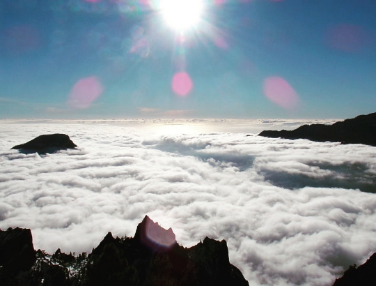
I knew that if we could push on for another hour in the last bit of fading daylight, we would drop below the snow line and our morale would raise. As we walked, the path became easier to tread and even managed to widen into a small road. We set a staggering pace along this road and our sheer determination for those hotdogs drove us on. Earlier on in the day Alex had been the driving force to get me over the ridgeline and keep me sane. But now, with just a few more kilometres ahead of us, he was starting to struggle, so I did all I could to motivate him for the final push. When we finally reached the refuge, we had walked for 15 hours and covered over 30 miles. We were well and truly shattered!
It was great to see Tim again! Although he had been unable to join us for much of our journey so far, he had become a vital support system in helping us reach each days target camp. He had made us hotdogs and suprised us with various calorific treats. Sitting down, I felt a huge weight had been lifted from my shoulders. Tomorrow, we would walk once again as a team of three and with only 20km left to cover on our final day! That was a beautiful thought indeed.
Day 5: The final push south
I awoke with my body feeling sunburnt and bruised from the previous days epic hike along the icy ridge. But mentally I felt fantastic, I’d slept well and knew that today would be a much easier and more enjoyable hike towards our end goal, the Southern most point.
We left the refuge with our bellys full and set off at an enjoyable pace through the refuges forest, back towards the Islands ridgeline. Our route was now more of an ash laden forest path with huge pine trees towering over us. The cloud inversion below was moving slowly and looked truly majestic as it crawled through the valley.
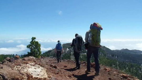
I was enjoying this path and the aches and pains had been completely forgot about as the adrenaline of reaching the end spurred me on. We drove forward and even climbed a few of the Islands smaller volcanoes on our way down.
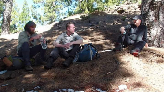
On reaching the final summit, our view into the Islands volcanic crater had totally disappeared, there was a huge feeling of sadness, yet satisfaction all at the same time. The walk along the Islands ridgeline had been one of the toughest walks in my life, but also one of the best. Over the past five days, I had come to learn why the island deserved its title as one of the most beautiful, and how it had earned its classification as the worlds steepest.
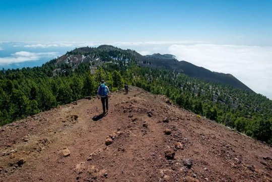
Photo by Alex Frood
We dropped down into the Islands southern most town, Fuencaliente. From here the Southern most tip was now only a few miles away. We stopped in a small cafe for a sandwich and a can of coke and spoke fondly about the journey we had undergone over these past five days. We arranged for a taxi to meet us at the Southern point and we set off in high spirits to finish our journey ahead of sunset.
The final stretch took us through a field of hardened magma, a scene that seemed frozen in time since the Islands last volcanic eruption that took place at Teneguia in 1971. We had to walk around Teneguia, as entry to the volcano required payment, which felt a bit strange after summiting all of the Islands volcanoes previous to this one.
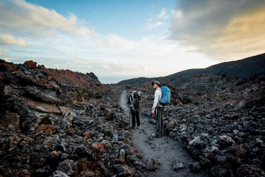
Photo by Alex Frood
We eventually reached our last descent down an ash laden path, taking long jog like strides which created thick clouds of volcanic dust. The adrenaline was pushing us downwards, our sights fixed on the Southern most tip. We could see the lighthouse looming in the distance, marking the end of our journey. After five days of pushing ourselves to the limits across rugged terrain, through hugely diverse landscapes, battling the elements of the wet and windy coastal gullies of the North, the hot, humid jungles of the East, the high, icy volcanic peaks at the centre and then the hot and dry dusty paths of the South, our goal was within our grasp.
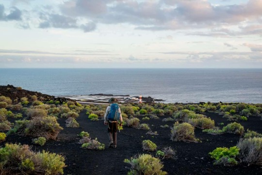
Photo by Alex Frood
Our final steps took us down onto a road which led us past the lighthouse to the Islands rocky Southern tip. The ocean stretched out before us, the feeling of accomplishment was immense and as the sun started setting over the horizon, we felt truly honoured to have experienced everything this magnificent Island has to offer. It was a place we had seriously underestimated, both in beauty and in brutal ruggedness. Through everything the Island threw at us, all the obstacles we faced, and even when we had been forced to split and take separate paths, we had worked together as an incredible team on this worlds steepest Island expedition and I can’t thank Alex and Tim enough for being part of such an incredible and memorable experience.
- Traversing La Palma, Chaz Powell.
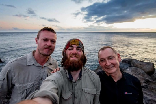
Photo by Alex Frood
Watch our journey here - https://youtu.be/YcM3fFfAerw #TraversingLaPalma #ChazPowell #TheWildestJourney #LaPalma #Trekking #Adventure #Travel #Island #Volcanoes #Caves #Jungle #Cloudforest #Mountains
